Subsidence is common in the Netherlands, with both natural tectonic compaction and human-induced subsidence occurring. Upheaval also occurs in a few places. Induced subsidence can be caused by mining activities, as well as by water management and civil engineering activities near or on the earth's surface.
KEM's research focuses on improving the monitoring, understanding and quantification of the origin of mining-related ground deformation (source), the propagation of ground motion to the surface and the resulting hazards (path), and the impact on the built environment, people and the wider environment (impact).
More ...
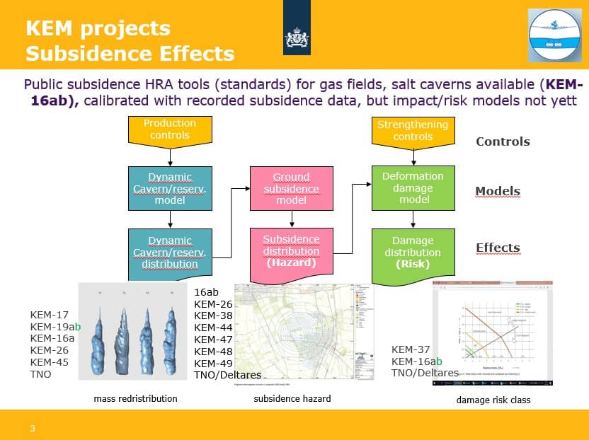
Image: © KEM / KEM
Focus of KEM projects on Subsidence Effects
Quite a few KEM projects are concerned with subsidence hazard and risk. These projects aim at developing better scientific insights for better subsidence hazard and risk assessment instruments and risk management practices.
In figure at the bottom of this page, KEM research (project numbers) can be found and their focus on, being source, path or impact, of subsidence risks.
The research questions, project deliverables and the evaluation of each finished project can be found under KEM projects. The research questions not (yet) addresed can be found under KEM research questions.
In order to assess subsidence hazard and damage and safety risks, subsidence can be predicted using various public subsidence models for gas, salt, coal and geothermal activities.
Partly realised by KEM research, a publicly available probablistic subsidence hazard toolkit for gas and salt mining has become available since 2022 at TNO. It also incorprates cumulative subsidence effects of multiple mining activities. A comprehensive public model for land subsidence hazard, damage and safety risks is still under development.
Similar publicly available tools for geotermal and CO2 or H2 storage are not yet available and ad hoc tools are currently used to assess thos subsidence effects.
Local geodetic subsidence monitoring network are since 50 years common practice for all mining operators. Since circa 2000 also nation-wide satellite information has become available (GNSS, InSAR). All data are publicly available.
A geodetic subsidence monitoring industry best practice protocol exists since 2015, which recommends for mining activities the methods, the instrumentation, the monitoring protocol and possible mitigating measures. This protocol and the instrumentation are generally accepted. Recently developments occur to include and integrate satellite data with geodetic data.
All subsidence monitoting data of operators can be found on Subsidence | NLOG.
Nation wide subsidence monitoring data can be found on Bodemdalingskaart .
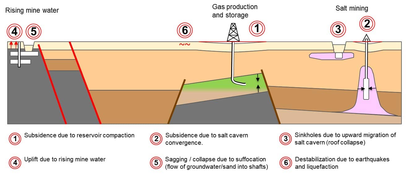
Image: © KEM / TNO
Schematic figure of potential subsidence effects of mining